Dear Neighbors,
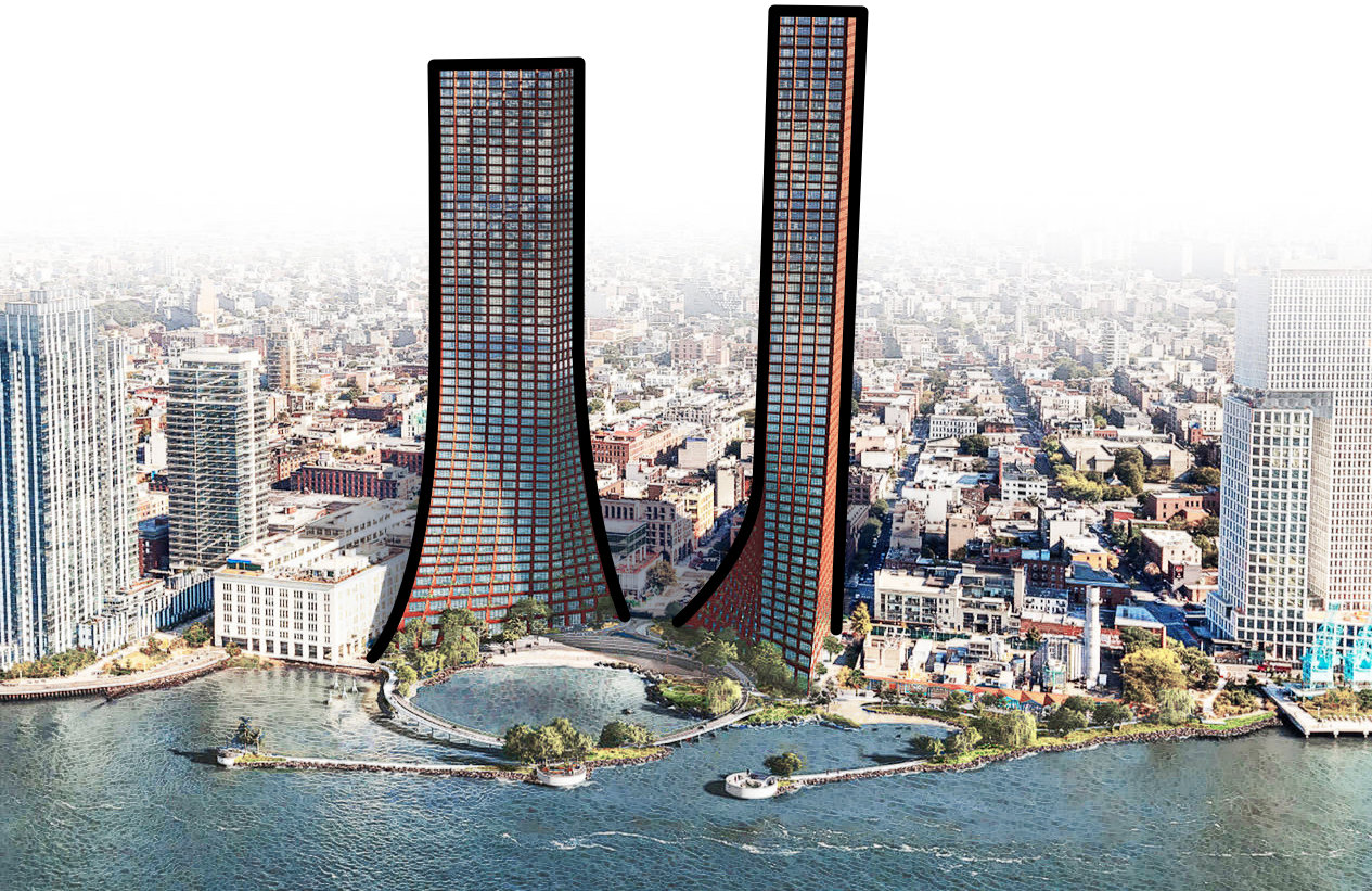
The developers of River Ring are asking the community to agree to a massive rezoning so that they can build 60 & 65 story towers on 87–105 River St. (North 3rd to South 1st St), the last two low density lots on the Williamsburg Waterfront.
The rezoning request would allow residential development more than 3.5x the density and ~6x taller, essentially doubling the value of their site. Their request includes a 35 year tax abatement, worth hundreds of millions of dollars in exchange for the ~2.9 acres of walk-able park space and 25% affordable housing.

Our city desperately needs money to recover, we need to end the practice of giving wealthy developers massive tax breaks that should be given to schools, infrastructure, the MTA and actual affordable housing.
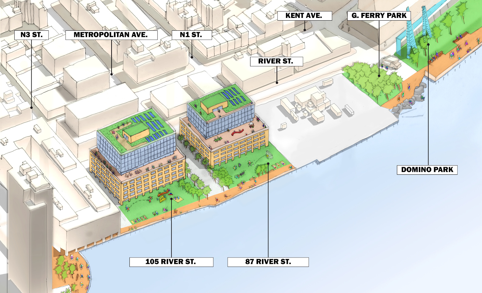
This project will go through the ULURP (rezoning process) later this year and it is our choice as a community what we would like to see on this site. Below is a basic render of the site as could be built in its current zoning.

(This image is meant for illustrative purposes only)
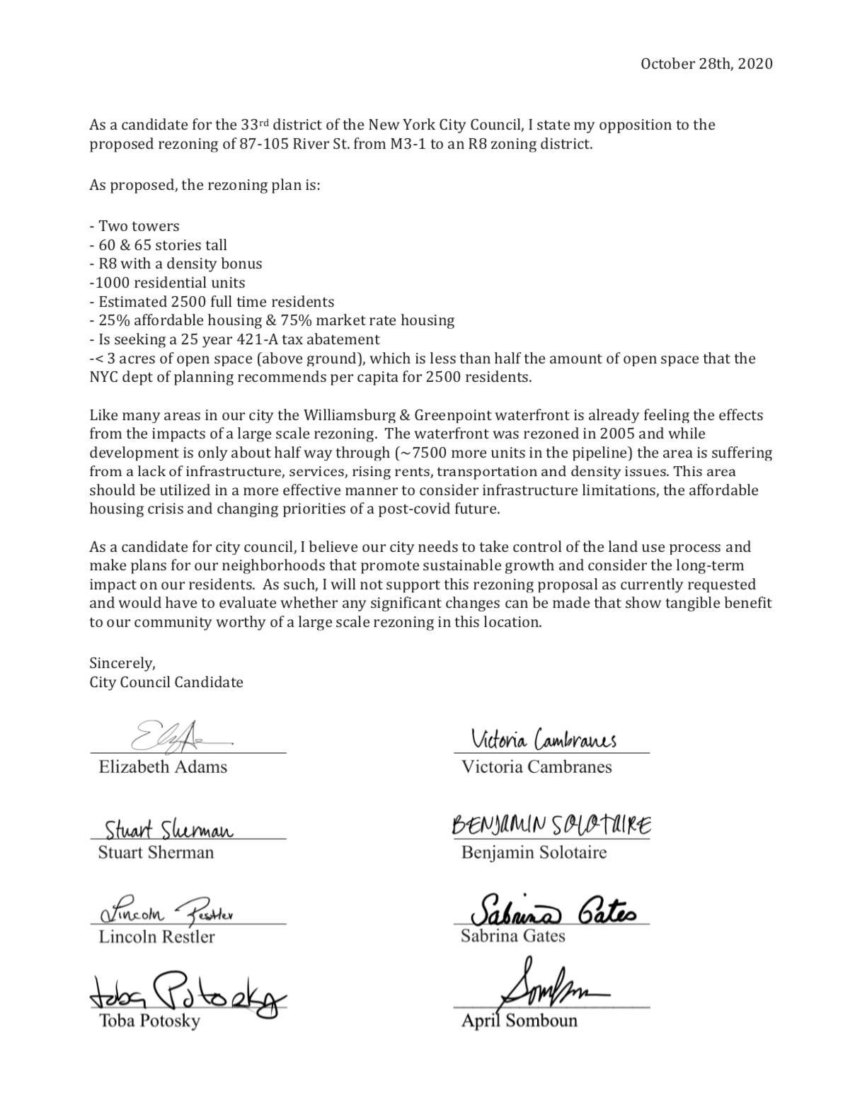
The developers are pushing this rezoning to happen during a pandemic because the decision maker is our current city council member, Stephen Levin, whose term ends this year. All eight candidates running for Levin’s seat are against this project, as seen in the letter below.
Please find us at Sustainable Williamsburg to stay in the loop and get involved in the future of our neighborhood.
Sincerely,

All Eight City Council Candidates
Stand Against This Project

River Ring Fact Check
The River Ring website and materials are heavily curated; skewed to the developer’s interests and contain many misrepresentations as found below.
We do not consider a 60 & 65 story tower on the waters edge in a time of global warming, a “waterfront resiliency plan.” Nor do we consider the developers money making plan to be our community’s “waterfront master plan.” While we cannot comment on their breakwater technology, at a glance, it seems like they are attempting to protect their enormous investment and if history serves us, most attempts to keep water away are only temporary fixes.
While a residential rezoning of the site would provide construction jobs temporarily, if the site is kept in current manufacturing or commercial zoning, it would provide full-time jobs without the increased full-time density of 2,500 residents.
Below is a fact check to their FAQ section. Please contact us or visit SustainableWilliamsburg.com to learn more and get involved.
Facts
 The developer is seeking a 421-a tax abatement in exchange for the affordable housing and park space, which means they will receive 35 years of tax breaks worth hundreds of millions of dollars.
Facts
 Two Trees presented at the January 2020 CB1 Land Use meeting. The presentation was met with opposition and was so well attended that they had to refuse people at the door and a second meeting was scheduled to accommodate the interest. There have been no public meetings since this initial meeting.
Facts
 The developer is assuming that the rezoning process is a done deal without acknowledging that the rezoning process requires community engagement and a real examination of the impacts of rezoning a site that was purposefully left with its current zoning during the comprehensive 2005 rezoning.
The developer is only midway through with the Domino Site next door. It is only reasonable for the community to consider the impacts of 3 more buildings on this block before being asked for another rezoning. Please finish one project before asking for another!
Facts
 The meetings were by invitation and focused on the park space only. At those meetings Two Trees intentionally limited to discussion about what the community would want in a new park and Two Trees refused to address their proposed buildings including their planned size.
Facts
 The developer is currently holding back their affordable housing units at the 1 South 1st building at the Domino Development, more than 16 months after releasing their luxury rentals. How can we trust they will deliver these affordable units if they cannot fulfill their commitment at their current site?
According to the Department of City Planning, there have been 2,100 new affordable units created in this area since 2007. Within the City Environmental Quality Review (CEQR) study area of the proposed River Ring project (which represents a mile radius of the site), there will be 1,300 affordable units, including the 700 affordable units at Domino.
The 250 proposed affordable units would represent a 12 percent increase in the number of affordable units in Community Board 1 (CB1) and represent a 19 percent increase within one mile of the site. Including the affordable units at Domino, Two Trees’ efforts would increase affordable housing within a mile of the site to 1,566 units from 616 units, a 250% increase representing a significant economic diversification of the area. They will be high-opportunity affordable units with access to the immediate neighborhood’s safety record, good schools and ample open space.
Facts
 The proposed development includes 25% affordable housing in exchange for the developer receiving a 421-A tax abatement worth hundreds of millions of dollars. How much truly affordable housing could be built with 200–300M+?
Studies show that unless a development is more than 50% affordable housing (this proposal is at 25%) the development’s overall impact is to raise neighborhood rents thereby causing further displacement. This type of development creates a circular problem for affordability whereas the affordable units act as a band-aid for the displacement caused by the luxury units.
Lastly, it is inappropriate to evaluate the impact of this proposed rezoning by including affordable units already required as part of the 2005 rezoning at the developer tries to do here in combining this with the Domino numbers. This project needs to pass ULURP’s rezoning process on its own merit or lack thereof.
As part of the required environmental impact review for the proposed project, Two Trees will conduct a traffic analysis and impact study for the proposed development. Preliminary studies show that an as-of-right, manufacturing use on the property (consisting of a last-mile delivery facility with retail, office and parking) would create significantly higher vehicular traffic than the proposed residential development. In fact, initial projections show that vehicular trips for Two Trees’ proposed plan are 40 percent lower than the estimated trips for the as-of-right option. The proposed residential plan would generate less truck, auto and taxi trips than an as-of-right plan under existing zoning.
Two Trees is also committed to creating a Working Group that meets regularly with neighbors, the DOT and local elected officials on solutions to long-standing traffic issues along River Ring and Kent Avenue. As long-term owners, we often share interests with neighboring buildings and residents on quality of life issues, including traffic.
As part of the required environmental impact review for the proposed project, Two Trees will also study impact on air quality. Due to the lower number of vehicular trips generated under the mostly residential River Ring proposal, impacts on air quality associated with additional traffic would be far less under the proposed plan.
Facts
 The rezoning they are proposing is more than 3.5x the size that the current zoning allows. The current zoning would likely result in retail or light manufacturing space, which is likely M-F 9-5, providing jobs to our neighborhood and keeping people in Brooklyn. At their count, 2,500 residents, 500 employees and hundreds of park goers. Which option do you think will cause more traffic?
Facts
 Over 3 acres of their open space is in the East River. The city guideline for open space is 2.5 acres per 1,000 residents. The developer is offering 2.9 acres above ground open space for their 2,500 residents. This means they are providing 1/2 of the recommended amount of open space for their own residents. As a result, if this plan is approved, the neighborhood would not gain open space; it gains density.
River Ring is designed to be consistent with the R8 residential zoning that dictates the waterfront development north and south of the site while maximizing public open space and protecting views. In general, accommodating this zoning requires one of two approaches: either a tall and thin building on a compressed footprint (like at Domino) which maximizes open space and the ground level public realm or shorter and fatter (like the buildings north of the site), which results in a more traditional waterfront esplanade on a bulkhead. In an effort to create this unprecedented waterfront park, we’ve chosen to compress the buildings into slender towers that quickly taper to the dimensions of 70 feet wide by 150 feet long. The base of the building is slightly wider to support neighborhood-level retail and the YMCA. As designed, the buildings are at least 60 feet from any other building and take up less than 15 percent of the total lot area to maximize the public park. While traditional waterfront zoning requirements would mandate that only 0.7 acres of the lot be dedicated to the waterfront esplanade and open space (as exists along the waterfront north of the site), we are proposing to create three acres of park and another three acres of newly created accessible in-water recreation areas.
As noted, the proposed density is consistent with the waterfront zoning north and south of the site. In fact, when you consider the private streets and roads at Domino and the northside projects that generated floor area for those developments, this project is effectively less dense than what exists to the north and south. Making the project smaller would inhibit our ability to deliver 250 low-income housing units and the $100M+ investment in the new park and its resiliency measures.
Facts
 They are proposing a 60 & 65 story towers. The Williamsburg/Greenpoint waterfront allows for 40 stories or less. The developer received a controversial exception at the Domino Site to build 50 stories. Further, the developer is presupposing that R8 zoning is the only acceptable solution, there is a wide array of smaller zoning options between what it is and what they are proposing. The zoning they are requesting more than doubles the value of their site. Keep in mind, they can also choose to sell the site for a profit immediately after rezoning and without delivering on their promises.
The as-of-right scenario for the site would likely produce a last-mile delivery facility with additional office space, large format retail and up to 1,600 parking spaces. The site layout would allow for a bulky 15-story building that would block all pedestrian views of the river. There would be no required waterfront esplanade, no park or open space and no affordable housing.
While there is some flexibility in the possible as-of-right use, in most cases the environmental impact from traffic, noise, air quality and open space would decrease the quality of life for the surrounding buildings and the neighborhood, and leave the immediate area vulnerable to future storm events.
Facts
 This is a scaremongering tactic. The current zoning would likely produce a building 8 stories or less and ~5x smaller. The current zoning can be seen across the street at 200 Kent where Trader Joes is expected to be the tenant. The FAR (floor area ratio) is 2, which means the building can be twice its lot size, or 1 full story if at the full lot, 2 stories covering ½ the lot, 4 stories at a ¼ of the lot, etc. Given this, it doesn’t make sense for a developer to build much higher than 6 stories.
Facts
We have heard this before in other developments and still have not seen results.- Sign the letter to Councilmember Levin
- Sign the petition
- Follow us on Instagram
- Stay in the loop at Sustainable Williamsburg
- Want to get more involved? Work with us!